SATELLITE IMAGE PROCESSING TECHNIQUES


Product Quick Detail
- Minimum Order
- 25
- Place Of Origin
- Changchun City, Jilin Province.
- Packaging
- Whole scene delivery / Mosaic delivery
- Delivery
- 7 days - within 2 months
Specifications
SATELLITE IMAGE PROCESSING TECHNIQUES
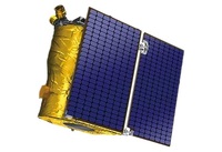
SATELLITE IMAGE ACQUISITION SYSTEM
SATELLITE IMAGES FOR IMAGE PROCESSING FEATURES
1
Satellite image processing system is the core of preprocessing of satellite images after landing.
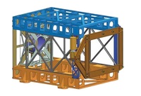
2
The system decrypts and decompresses the received original code stream data, completes the analysis and processing of auxiliary data, and then catalogues the data.
If you want to know more details of image processing of satellite images, please visit our website.
CGSTL (Changguang Satellite Technology Co., Ltd) is the first commercial remote sensing satellite supplier in China. Now, CGSTL has set up a commercial business dealing with the development and
operation of commercial satellites as well as remote sensing information processing all in one.
- Country: China (Mainland)
- Founded Year: 2014
- Address: No. 1299, Mingxi Road, Beihu Technological Development Zone, Changchun City, Jilin Province.
- Contact: jl1global com